The Analytical Foundation for Your Most Critical Assets
As Alma continues to expand its footprint as a vital hub for the Coastal Plain’s timber and manufacturing industries, the requirement for pinpoint accuracy in land data has never been higher. For civil engineers and site supervisors across Bacon County, outdated manual surveying techniques can no longer keep pace with modern construction and land management schedules. almaagdrones.com offers a paradigm shift in how regional projects are mapped. We move beyond simple "drone photography" to provide sophisticated geospatial intelligence that serves as the definitive record for your project’s lifecycle.
Our methodology is specifically designed to overcome the hurdles of surveying in Southeast Georgia: eliminating the dangers of unstable terrain, reducing the high overhead of traditional aircraft, and providing clarity where flat, featureless landscapes often hide drainage issues. Utilizing Blue UAS certified platforms paired with world-class sensors, we capture millions of survey-grade data points across vast acreage in hours rather than weeks. Whether you are managing an Alma-area aggregate site or planning a multi-mile corridor for regional infrastructure, our data integrates flawlessly into your existing CAD and GIS ecosystems.
Mission-Critical Security: Blue UAS Integration
In an era of heightened digital threats, the confidentiality of your site’s layout is a top priority. Every survey system deployed by our team is Blue UAS Certified, meaning it has successfully cleared the rigorous cybersecurity and supply chain vetting required by the U.S. Department of Defense. For those overseeing critical infrastructure in and around Bacon County—from electrical substations to municipal water systems—this certification guarantees that your sensitive data is shielded from unauthorized access at every stage of the process.
Volumetric Analysis: Redefining Stockpile Management
For the industrial and aggregate firms operating in Alma, the ability to quantify inventory with absolute certainty is essential for both the bottom line and regulatory compliance. Conventional "walk-on" surveys are not only time-intensive but pose significant safety risks to personnel navigating shifting piles or steep quarry walls. Our aerial solutions remove the human element from the danger zone while simultaneously increasing the frequency and precision of your measurements. We utilize 61MP full-frame sensors to generate hyper-realistic 3D reconstructions of your entire yard.
By processing this imagery through the PIX4Dmatic engine, we produce auditable reports for cut/fill and stockpile volumes with centimeter-level precision. For financial controllers and facility managers in Bacon County, this means the stress of monthly reconciliation is a thing of the past. We deliver a transparent, verifiable record of your materials that can be analyzed and shared across your leadership team within 24 hours, turning your physical inventory into a fully measurable digital asset.
LiDAR Mapping: Piercing the Coastal Plain Canopy
Bacon County is defined by its sprawling timberlands and dense pine canopies, which present a unique challenge for traditional optical mapping: the ground is often invisible from the air. To design effective drainage systems or plan new developments in the South Georgia Coastal Plain, engineers must see the true topography beneath the vegetation. This is why our LiDAR (Light Detection and Ranging) services are indispensable. We utilize the Riegl miniVUX-2UAV, an elite-tier sensor specifically engineered for maximum vertical precision.
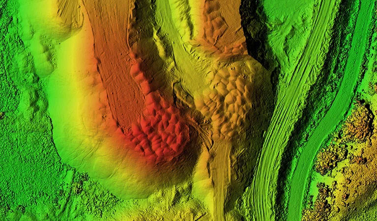
LiDAR functions by emitting millions of laser pulses every second that find gaps in even the most stubborn foliage. These pulses reflect off the forest floor, allowing us to generate a "bare earth" Digital Terrain Model (DTM) that optical cameras simply cannot produce. For Alma developers reclaiming land or engineers tackling complex runoff issues, this data is transformative. Our LiDAR flights offer vertical accuracy better than one inch and point densities of up to 800 points per square foot, exposing hidden terrain features that would otherwise go unnoticed until the bulldozers arrive.
Wide-Area Mapping & Fleet Deployment
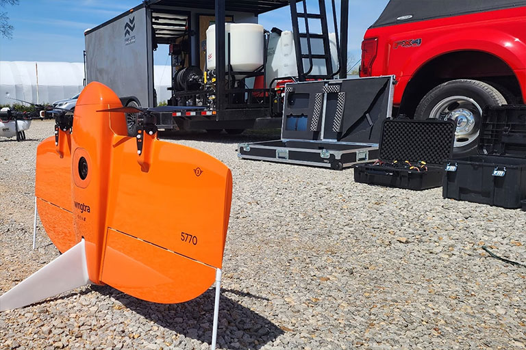
Regional infrastructure and large-scale agricultural projects require a different approach to scale. While standard drones are limited by battery life and range, our fleet includes the WingtraOne Gen II—a vertical take-off and landing (VTOL) fixed-wing craft capable of mapping over 700 acres in a single flight. This allows us to cover ten times the territory of a quadcopter in the same timeframe. For the most ambitious projects in Bacon County, such as new industrial parks or massive blueberry tracts, we deploy synchronized aircraft and crews to capture data in parallel.
This high-efficiency data collection allows us to map thousands of acres in a single day without compromising on resolution. Our workflows utilize integrated PPK (Post-Processed Kinematic) technology, ensuring every data point is geotagged with extreme precision while minimizing the need for ground control points. This results in a faster turnaround and a smaller physical footprint on your site, providing a comprehensive dataset ready for immediate land development planning.
3D Digital Twins & Property Visualizations
Bring your project to life with photorealistic 3D digital twins that go far beyond the capabilities of a 2D blueprint. Traditional site plans often fail to communicate the true spatial relationships within a complex environment. We create immersive, high-resolution 3D models that empower Alma stakeholders to visualize and inspect their assets with unprecedented clarity.
By blending vertical and oblique imagery, we develop textured 3D meshes and point clouds that serve as a permanent "as-built" record. This technology is the gold standard for tracking construction milestones, conducting sunlight/shadow analysis, and marketing premier commercial properties in Bacon County. For local developers, a digital twin offers a verifiable chronological record of progress, ensuring every phase of construction aligns with the original engineering specifications.
Technical Accuracy Metrics
Horizontal Precision
1.0 cm
PPK-Enhanced Data
Vertical Accuracy
< 2.5 cm
Advanced LiDAR Terrain Mapping
Ground Sampling Distance (GSD)
0.7 cm/px
61MP Full-Frame Clarity
Comprehensive Project Management
Your dedicated Tattnall County Project Manager handles the entire lifecycle of your data, from initial site scoping and sensor optimization to final delivery in Pix4Dmatic. We provide data in the exact formats your engineers require: DXF, DWG, LAS, and GeoTIFF.
Request Technical Consultation